Scope of Project
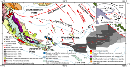
In eastern Papua New Guinea, the westward propagating Woodlark Basin sea floor spreading center terminates along strike into one of the most rapidly extending rifts on our planet- the Woodlark Rift. It is in this region of active and rapid extension, that Late Miocene-Pliocene eclogites have been exhumed within the lower plates of metamorphic core complexes (MCCs) at cm/yr rates.
We are using eastern Papua New Guinea (PNG) as a field laboratory to examine how the lithosphere has evolved petrologically, rheologically, and thermally during the transition from subduction to rifting and seafloor spreading. Two key questions in continental dynamics are addressed in this research: How does lithosphere rupture? How are HP/UHP terranes formed and exhumed?
Geologic Fieldwork
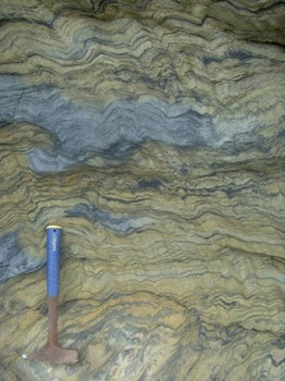
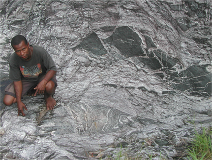
Geologic fieldwork is documenting the spatial distribution, temporal sequence, and kinematics of ductile to brittle fabrics in metamorphic, magmatic and sedimentary rocks of the conjugate rifted margins, the D’Entrecasteaux Islands west of the active seafloor spreading rift tip, and the inferred youngest metamorphic core complex (Dayman Dome). Analytical work is providing constraints on the pressure–temperature–time–deformation evolution of exhumed rocks, as well as the melting conditions and sources that have given rise to volcanic rocks. A passive seismic deployment will image the crust and mantle beneath and north of D’Entrecasteaux Islands where partially exhumed HP/UHP rocks may occur at depth. Rock physical properties modeling will integrate petrophysical lab measurements of HP/UHP field samples, electron back-scatter diffraction studies of lattice preferred orientations, and quantitative mineral-physical-properties calculations for determining seismic wave speeds of rocks. GPS surveys will provide direct measurements of horizontal strain rates associated with HP/UHP exhumation and microplate kinematics. Geodynamic modeling will numerically simulate MCC evolution and exhumation of HP/UHP rocks. All data will be integrated by tectonic synthesis to test end-member models proposed for the tectonic evolution of the region and address the two key questions above. The eastern Papua New Guinea HP/UHP terrane will be compared to similar terranes globally to assess whether exhumation mechanisms documented in this region can be applied to other HP/UHP terranes. Results will contribute to an improved understanding of the processes governing the origin, structure, composition, and dynamic evolution of continental building blocks. These processes include deformation localization within the crust, exhumation of UHP rocks, and the fundamental processes by which the Earth’s tectonic plates rift and rupture.
This research will allow for a greater understanding of the natural hazards that exist at plate boundaries, such as the location of faults, earthquakes and volcanoes, and will provide additional insight into why and how the Earth’s lithospheric plate boundaries evolve over geologic time. Outreach activities include educating local communities about the volcanic and seismic hazards of their home area.
Principal investigators for the Papua New Guinea NSF Continental Dynamics project
Suzanne Baldwin (SU) directs the Syracuse University Noble Gas Isotope Research Laboratory. As lead PI she serves as project manager. She leads geologic expeditions in the Milne Bay Province, supervises SU students and post-docs, and collaborates in thermochronologic, petrologic, structural, isotope geochemical research and synthesis of results.
Geoffrey Abers (LDEO) has primary responsible for the on-land seismic data collection, routine processing, and data archive. He will collaborate on all aspects of seismic analyses, including tomography, scattered-wave imaging, and local seismicity. He is also collaborating with Brad Hacker in using seismic velocities to constrain composition, temperature and melt.
Roger Buck (LDEO) has primary responsibility for numerical simulations of metamorphic core complex development and the exhumation of HP/UHP rocks in eastern Papua New Guinea and will supervise a LDEO student. SU, BU, UCSB will collaborate with him to provide constraints for geodynamic models.
Jim Gaherty (LDEO) has primary responsibility for the Ocean Bottom Seismic data collection and processing, and will provide field support for the on-land seismic data collection. Jim has primarily responsibilty for surface-wave and anisotropy analyses.
Brad Hacker (UCSB) is collaborating with Matthew Salisbury to measure velocities and calculate velocities and other physical properties of Papua New Guinea rocks that can be used to i) evaluate seismic data and ii) constrain UHP exhumation models. He will also contribute to the geodynamic and tectonic synthesis.
Brian Horton (UT Austin) has carried out sedimentological mapping, dating, and magnetostratigraphic work on Neogene clastic units exposed in basins associated with the low-angle Owen Stanley fault along the northern edge of the Dayman dome.
Paul Fitzgerald (SU) heads the fission-track laboratory and has extensive experience in low-temperature thermochronology and its application to tectonics and landscape evolution. He has participated in fieldwork, undertaken and supervised fission-track and (U-Th)/He analyses and is involved in determining the landscape evolution and tectonic synthesis.
Paul Mann (UT Austin) has carried out field-based mapping of the Owen Stanley low-angle, oblique–normal fault in the area west of Goodenough Bay and along the edge of Dayman dome. He is supervising a graduate student, and an undergraduate field assistant from the University of Papua New Guinea.
Terry Plank (BU) will oversee the geochemical analyses of volcanic rocks, and the study of melt inclusions in recent volcanics. She will participate in sample collection, and supervise undergraduate and graduate students involved.
Laura Webb (UVt) is involved in mapping, structural analyses (kinematics of ductile and brittle deformation, fault-slip analyses, and microstructural analyses), petrography, and thermochronology. Her contribution to the tectonic synthesis will include how results from Papua New Guinea relate to worldwide UHP terranes.
International and National Collaborators working on this project also include:
Hugh Davies (University of Papua New Guinea Papua New Guinea; geologic and tectonics)
Tim Little (Victoria University of Wellington; structural geology)
Laura Wallace (N.Z. Institute of Geologic and Nuclear Sciences; geodesy)
Nathan Daczko (Macquarie University; Dayman Dome structural geology/petrology)
Susan Ellis (N.Z. Institute of Geologic and Nuclear Sciences; crustal dynamics geophysics)
Simon Kawagle (University of Papua New Guinea; on-land seismic data collection)
Ian Smith (Auckland University; geochemistry of volcanic rocks)
Jeff Vervoort (Washington State University; (U/Th)/Pb detrital/inherited zircon analyses, Sr–Nd–Hf–Pb analyses)
Andreas Mulch (Hannover University; stable isotope geochemistry)
Matthew Salisbury (Geol. Survey of Canada; seismic velocity measurements).